
Page 68 - Upland Families, Elites and Communities
P. 68
Markéta Skořepová
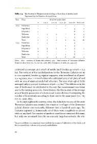
Table 2.3 The Number of Homesteads According to Their Area of Arable Land
Expressed by the Number of strych/korec
Year Place Strych of arable land
.– .– .– .– .–
Pobistrýce – – –
Popelištná – – – –
Svépravice – – –
Těchoraz – –
Zmišovice – – – –
Total
Pobistrýce – –
Popelištná – – – –
Svépravice
Těchoraz – – –
Zmišovice – – –
Total
Notes 1674 – revision of Berní rula cadastre, 1757 – final version of Theresian cadastre.
Basedon data from na, tk,inv.no. 3056, 886;Chalupa et al.1966, no. 1347, 327.
cultivated on average 46.6 strych of arable land (median 40 strych =11.3
ha). The revision of the tax declarations to the Theresian Cadastre set up
in 1722 captured, besides 35 regular taxpayers, who were listed in all previ-
ous registers, also 11 minor holders who cultivated very small plots of land
with an area of approximately half a hectare. The area of ploughed fields
averaged only 17.9 strych (median 20 strych = 5.7 ha).⁹ The difference in the
size of fields must be attributed to the way the measurement was taken
and to the varying area units. Nevertheless, the diminution of the average
area of land in possession of a homestead is also obvious if comparing the
number of homesteads according to their size in the same years (na, tk,
inv. no. 3056, 886).
In the mid-eighteenth century, when the definitive version of the state
Theresian Cadastre was created, the situation in villages of the Zmišovice
judicial district was noticeably different than a hundred years ago. The
Cadastre captured 51 homesteads; 16 of them were completely or almost
without any land. The number of medium-sized farms remained the same,
but only one remained from the enormously large homesteads; the oth-
⁹ The protocol from 1722 examined very carefully the manner of cultivation of the fields, and
the computed data includes only actually seeded fields.
66